Key Takeaways
- ✅
The Wild Atlantic Way stretches 2,500 km from Donegal to Cork.
- ✅
The island of Ireland is divided into two countries; Northern Ireland and the Republic of Ireland.
- ✅
The Wild Atlantic Way is one of three official touring regions in the Republic of Ireland, alongside Ireland’s Ancient East and Ireland’s Hidden Heartlands.
Do you know your Wild Atlantic Way from your Ancient East? VagaGuide and travel expert Brian gives some basic facts about Irish geography in this fun and informative blog.
The Wild Atlantic Way in Ireland At A Glance
- 💚 Where exactly is the world-famous Wild Atlantic Way?
- ✌️ Ireland is 1 island with 2 countries; Northern Ireland and the Republic of Ireland
- ☘️ Ireland is not connected to Britain (though, at its closest, Scotland is only 12 miles away)
- 💶 Both Irish states have their own capital city and currency
- 🗺️ Ireland is divided into 32 separate counties and four provinces.
👋 Hi, I’m Brian — VagaGuide and Senior Digital Marketing Executive at Vagabond & Driftwood Tours.
From planning a scenic Wild Atlantic Way Tour to simply getting your head around the geography of Ireland, our Vagabond & Driftwood Community Group has been asking for a handy Ireland facts guide for a while now.
And who are we to refuse the VagAlumni?
Maps. Counties. Capital cities. Currency. Wild Atlantic Way facts.
Read on, intrepid Vagabond, for the Ireland basics you’ll want to know before your next adventure.
💚 Where Is The Wild Atlantic Way in Ireland?
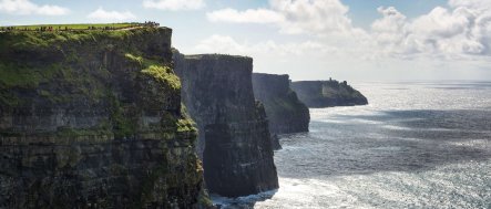
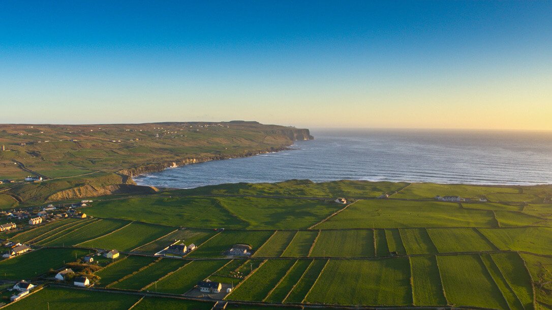
The Wild Atlantic Way Ireland route stretches 2,750 km — or 1,700 miles — along Ireland’s dramatic west coast.
This scenic coastal route runs from Donegal in the north to Cork in the south, passing cliffs, beaches, islands, colourful towns and incredible Atlantic views.
It’s one of three official touring regions in the Republic of Ireland, alongside Ireland's Ancient East and Ireland’s Hidden Heartlands.
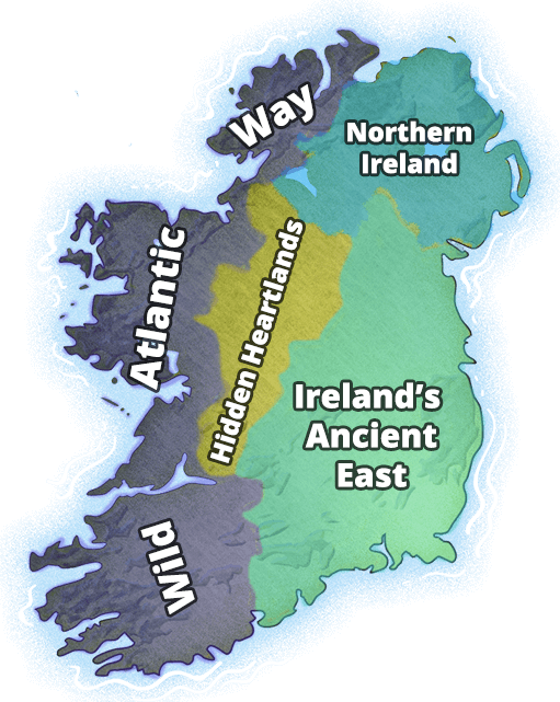
The Wild Atlantic Way has one end in Cork, in the south, with its other end in Donegal, in the north.
Although the route itself hugs the coast and is signposted all the way, there are endless opportunities to detour off the Wild Atlantic Way to surrounding towns and attractions.
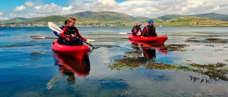
What's the best tour of the Wild Atlantic Way? You'll know this amazing route like the back of your hand after our 8 Day Wild Atlantic Way Tour.
☘️ Is Ireland Part Of The UK?
Only one portion of Ireland is part of the UK.
Part of the island of Ireland — Northern Ireland — is part of the UK (United Kingdom).
Northern Ireland is located in the north and northeastern corner of the island.
Northern Ireland occupies about 20% of the entire landmass of Ireland as a whole.
This fact about Ireland is sometimes misunderstood. Visitors often assume the island of Ireland is either entirely independent or is 100% still part of the UK.
The truth is, the island of Ireland has a mix of both.
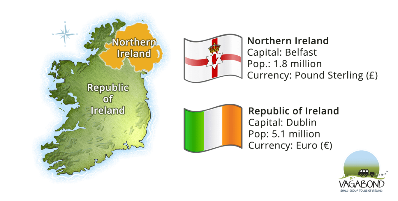 The larger portion of the island is called the Republic of Ireland (or, more normally, just 'Ireland').
Even though Northern Ireland is a separate state to the Republic of Ireland, you will hardly notice the physical difference while travelling.
There is no formal border crossing between the two countries. Conveniently, there are also no passport controls and no customs checks.
🇮🇪 Is Ireland Independent?
The Republic of Ireland is fully independent.
This has been the case for a long time; first as the Irish Free State (1922-1937) and then as the Republic of Ireland (1937-present).
It is no longer a part of the UK.
The Republic of Ireland, however, is part of the EU (the European Union trading bloc), unlike Northern Ireland.
🧭 Republic of Ireland or Southern Ireland?
The Republic of Ireland is sometimes referred to conversationally as 'the south' or Southern Ireland.
Why?
Well, because the vast majority of the country is located in the southern three-quarters of the island.
But, here's the kicker....
The northernmost county in Ireland is Donegal. It's in the Republic's territory and — confusingly — its northern tip lies further north than that of Northern Ireland.
Ireland is the only country in the world where its most northerly tip is located in the south…
Got it?
No?!
Good...
🏴 Is Ireland Connected to Scotland/England?
The islands of Ireland and Britain are not connected by land.
While parts of eastern Ireland are not far from parts of western Britain, travellers must use a plane or boat to visit each island.
The closest part of Ireland to Britain is the coast of Antrim in Northern Ireland.
The distance from Antrim to the Mull of Kintyre in Scotland is approximately 19km (12 miles) at its narrowest.
💶 Does Ireland Use The Euro?
The euro (€) is used in the Republic of Ireland.
As part of the UK, Northern Ireland uses the pound sterling (£).
Find out more about money, banking and credit cards in Ireland
What Is The Capital Of Ireland?
Two countries means two capital cities.
Dublin is the capital of the Republic of Ireland. It's also the largest city on the island.
All of our small-group tours depart from Dublin.
Belfast is the capital city of Northern Ireland.
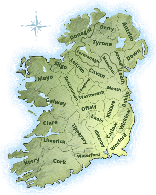
🗺️ The 32 Counties of Ireland
Ireland is divided into thirty-two counties.
There are 26 counties in the Republic of Ireland and 6 in Northern Ireland.
Each county has a principal town, its own crest and county colours. They even have nicknames!
The largest county in Ireland is Cork. It's known as the 'Rebel County'. Its traditional sporting colour is red.
The smallest county in Ireland is Louth. It's known as the 'Wee County'. Its traditional sporting colour happens also to be red!
Much pride and passion is expressed when different counties face each other in sport.
As you tour Ireland, watch out for 'county colour' flags flying from gateways, houses and shops.
⚃ Ireland's Four Provinces
Leinster, Munster, Ulster and Connacht are the four provinces of Ireland.
But unless you're a sports fan, Ireland's four provinces don't crop up in daily life too often.
Leinster, Munster, Ulster and Connacht are historical divisions. Long ago, they had their own rulers.
The people and accents of each province carry a distinct character. They're useful to gaining a deeper understanding of Ireland.
🧭 Which Counties Are In Which Irish Provinces?
Connacht has 5 counties:
- Galway
- Sligo
- Roscommon
- Mayo
- Leitrim
Leinster has 12 counties:
- Dublin
- Wicklow
- Wexford
- Carlow
- Kilkenny
- Louth
- Laois
- Longford
- Offaly
- Louth
- Meath
- Westmeath
Munster has 6 counties:
- Clare
- Cork
- Kerry
- Waterford
- Tipperary
- Limerick
Ulster has 9 counties:
- Antrim
- Down
- Derry
- Tyrone
- Fermanagh
- Cavan
- Monaghan
- Armagh
- Donegal
An important distinction lies between Ulster and Northern Ireland. While they cover lots of the same territory, Ulster has 9 counties but Northern Ireland only has 6. Donegal, Monaghan and Cavan are Ulster counties in the Republic of Ireland.
🚐 Ready For Your Irish Geography Practical?
We hope you've found these facts about Ireland interesting.
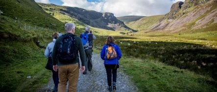
To experience the full glory of Irish geography, of course, you will need to get over here for a practical exam.
Take your pick from our small-group tours that follow the Wild Atlantic Way.
Or wander the wonderful byways of Northern Ireland.
Whichever destination in Ireland you choose, you'll be delighted to taste and discover the island's food renaissance, with amazingly fresh, local produce and fantastic restaurants around every corner.
Remember you can select an active and physical Vagabond Cultural Adventure or an easy-pace Vagabond Journey of Discovery.